List of Layers
Overview
The EDERA platform organises the product layers into five distinct blocks, each serving a specific purpose:
Dynamic Layers: The layers highlighted in blue are categorised as Dynamic Layers, which are updated with each new forecast.
Static Layers: The green block represents Static Layers, containing information that remains constant.
- Block 1: Flash flood forecast summary (0-120h)
- Official Warnings
- Seamless precipitation accumulations
- Flash flood impact over sub-catchment
- Block 2: Convective multi-hazard nowcasting
- Radar reflectivity
- Hazard probability nowcast
- Block 3: Animated Flash Flood nowcasting
- Seamless 1h precipitation accumulation forecast
- Flash flood hazard
- Flash flood impact over the river network
- Flash flood impact over sub-catchment
- Exposure
- Block 4: Flash flood past 24-h summary
- Precipitation accumulation (24h)
- Rain gauge accumulation (24h)
- Flash flood hazard summary (24h)
- Flash flood impact summary over the river network (24h)
- Flash flood impact summary over sub-catchment (24h)
- Block 5: Static Layers
- Exposure
- Flood Area (T1000)
- Flood Area (T050)
- Flood Area (T1000)
- Block 5: Static Layers
- Exposure
- Flood Area (T1000)
- Flood Area (T050)
- Flood Area (T1000)
Block 1: Flash flood forecast summary (0-120h)
Three products are generated within the EDERA project.
Official Warnings
These are summaries of warnings generated by the National Meteorological and Hydrological Services (NMHSs) across 37 European countries. Covering 12 types of hazards, these warnings are sourced from MeteoAlarm, developed by EUMETNET. The warnings are categorised as follows:
- Moderate (Yellow)
- Severe (Orange)
- Extreme (Red)
Seamless precipitation accumulations
Precipitation accumulations are forecasted over the next 5 days and displayed as summaries for four lead-time windows: 0-6h, 6-24h, 24-48h, and 48-120h. These accumulations are derived from a blend of radar observations and Numerical Weather Prediction (NWP) data:
- Radar Observations: 20-member ensemble of 1-h accumulation generated with the algorithm for probabilistic nowcasting by extrapolation of radar observations SBMcast (Berenguer et al., 2011) applied to the gauge-adjusted OPERA radar composites over Europe (2 km, 15 minutes; Park et al. 2019).
- NWP Data: 51-members ensemble of 1-h accumulation forecasts obtained by Numerical Weather Prediction with the ECMWF Ensemble Prediction System (EPS).
The blending technique (Wong et al. 2009) is applied for the first 6 hours and applies a phase shift and bias correction to blend radar nowcasts into NWP using a hyperbolic tangent weighting function. For lead times beyond 6 hours, the product relies only on the NWP forecasts from the ECMWF ensemble.
The displayed accumulations correspond to the 80th percentile of the forecast ensemble distribution, which represents a reasonable worst-case scenario.
Flash flood impact over sub-catchment
This product forecasts the impact level of flash floods at the sub-catchment scale over the next 5 days, segmented into lead-time windows (0-6h, 6-24h, 24-48h, 48-120h). The impact level is determined by intersecting the flash flood hazard forecast with the exposure layer (shown in the static layers block) on a risk matrix (see figure below). Both the flash flood hazard and the exposure data are split into three categories to create the risk matrix. Hazard levels are categorized into low (5%-50%), medium (50%-80%), and high (>80%), with probabilities of exceeding the 2-year return period threshold. This flash flood hazard is estimated by comparing blended forecasts of precipitation (from the OPERA radar mosaic and ECMWF NWP forecasts) accumulated on the river network, with the reference values derived from climatology. This climatology is from (i) 8-year gauge-adjusted OPERA data, and (ii) from a dataset of 20-year reforecasts obtained with ECMWF’s Integrated Forecasting System (IFS). The categories for low, medium, and high relative combined exposure respectively capture the variation in population density and critical infrastructure in rural, suburban, and urban areas in Europe. For more information on the exposure data, please see the documentation for that layer.
The above comparison between the forecast and climatology gives impact levels in each ~1.4 km grid cell along the river network. The maximum impact is calculated in each grid cell for each of the 4 lead time aggregation windows (0-6h, 6-24h, 24-48h, 48-120h). To then provide a quicker overview of the affected areas, this sub-catchment overview is created by shading the sub-catchments according to the 90th percentile of the impact level of all cells forecasted within it. The use of the 90th percentile of impact (instead of the maximum) is to avoid communicating potentially misleadingly high forecast information to users based on single cell values.
Each shaded sub-catchment can be queried to open a pop-out window which contains information about
- the classification of the impact matrix,
- the number of people, education, health and energy generation facilities potentially affected
- the time of the forecasted peak of the event.
The total population potentially affected is calculated as the number of people (sourced from the Global Human Settlement Layer dataset) who live within river grid cells within the sub-catchment with a risk matrix classification of yellow and above. This value should be interpreted as a very preliminary estimate, as it is based on spatially coarse ~1.4 km information and does not consider the role of protection measures such as flood defences.
Block 2: Storm Impact
Three storm hazard and impact product groups are generated within the EDERA project.
Meteorological layers
Reflectivity is the variable measured by radars. It relates to rain rate, R, through a relationship of the kind Z=aRb (where a and b are parameters that depend on the type of precipitation). The Radar reflectivity OPERA layer is produced by the EUMETNET project OPERA, composing the reflectivity observations of 200+ radars from 31 countries. The hourly precipitation-radar nowcasting layer shows hourly rainfall accumulation calculated from instantaneous rain rate mosaics provided by OPERA.
Every 15 minutes new forecasts of reflectivity and hourly rainfall accumulation are generated by extrapolating the radar observations for up to 6 hours with a nowcasting algorithm based on Lagrangian persistence (Berenguer et al., 2011).
Reference: Berenguer, M., Sempere-Torres, D., Pegram, G.G., 2011. SBMcast – An ensemble nowcasting technique to assess the uncertainty in rainfall forecasts by Lagrangian extrapolation. J. Hydrol. 404, 226-240. https://doi.org/10.1016/j.jhydrol.2011.04.033
Storm impact layers
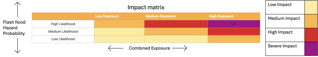
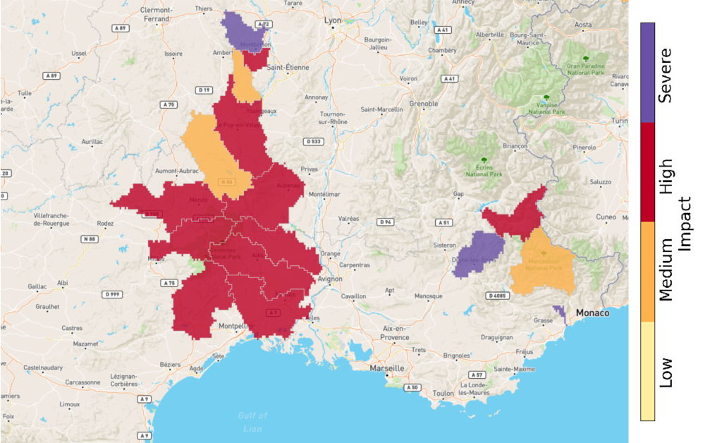
This layer shows a weather radar-based nowcasting product for multi-hazards and impacts caused by thunderstorms. The hazard types are heavy rainfall, wind gusts, hail, and lightning. In addition, a total hazard product is generated by taking the maximum hazard level from each of the above. Impact products are generated by combining the predicted hazard levels with an exposure layer.
These products combine cell-based storm nowcasts (Rossi et al. 2015) with a machine learning (ML) model to predict storm hazard levels. The hazard levels are storm-estimated based on historical meteorological observations and weather impact reports following the concepts described by Rossi et al. (2013) and Tervo et al. (2019).
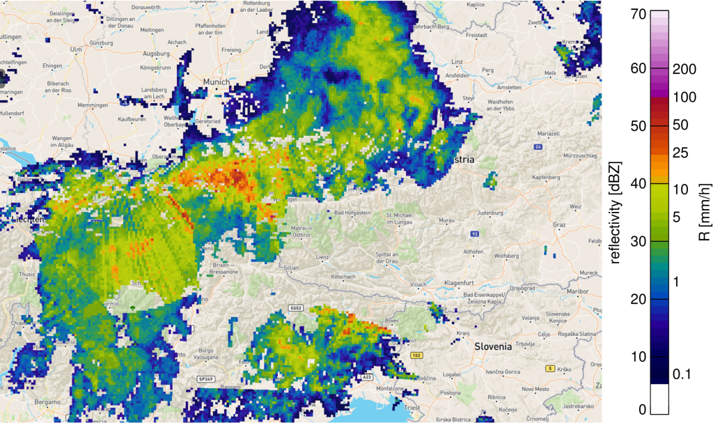
The storm impact layers combine meteorological data from various sources such as weather radar, Numerical Weather Prediction (NWP) models and ERA5 re-analyses. The weather impact reports are obtained from the European Severe Weather Database (ESWD). Probabilistic nowcasts for the future location of the classified thunderstorms for the coming 5-60 minutes are being produced by using a Kalman filter model (Rossi et al. 2015).
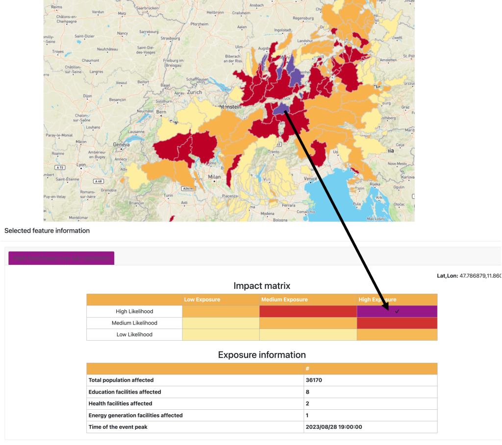
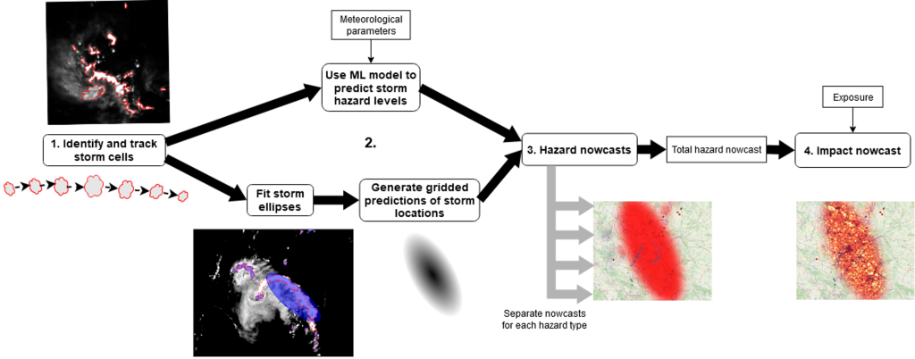
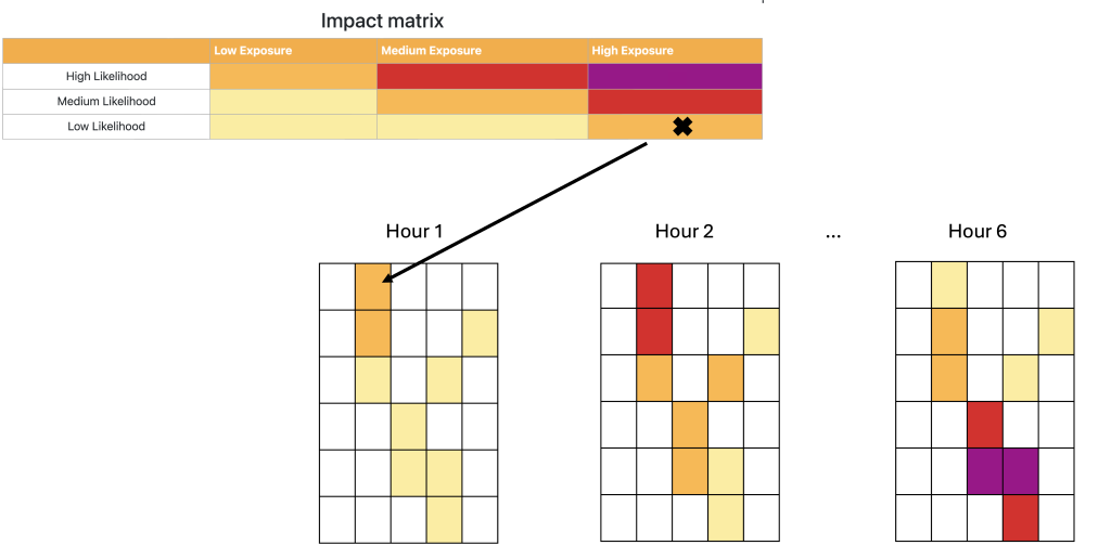
The product generation process is illustrated in Figure 1. Storm cells are identified and tracked from OPERA reflectivity composites (step 1). Hazard levels of the cells are then predicted with the ML model for the four different hazard types (heavy rainfall, wind gusts, hail and lightning). This is done by using meteorological information from additional data sources, such as ERA5 reanalyses (step 2). Ellipses are fitted to the storm cells, and probabilistic nowcasts of storm ellipse locations are produced by applying the Kalman filter-based model (step 2). The predicted hazard levels are combined with the storm locations, which gives the hazard nowcasts (step 3). Here we assume that the hazard levels remain constant during the forecast time range. The nowcast giving the total hazard level is generated by taking the maximum levels from each hazard type. Finally, the maximum hazard nowcast is combined with an exposure layer to produce an impact nowcast (step 4). This is done by using a single exposure data source combined with openly available datasets of population, transport and critical infrastructure (e.g. health, education and energy).
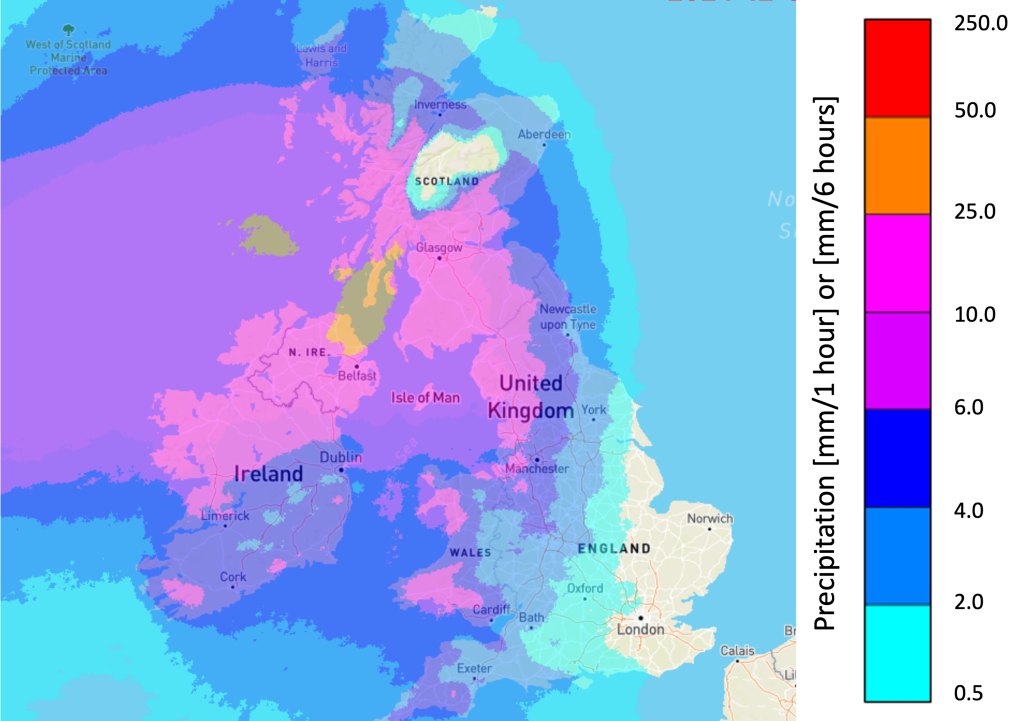
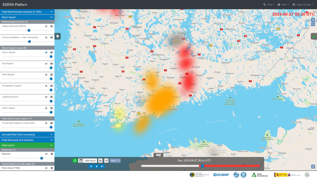
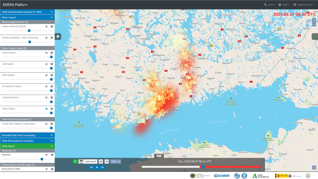
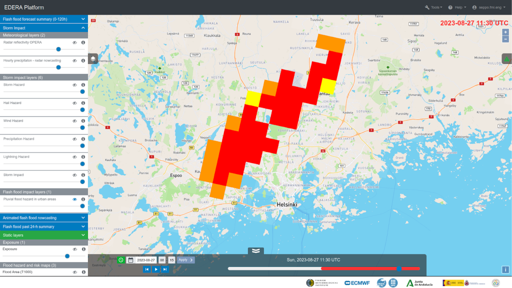
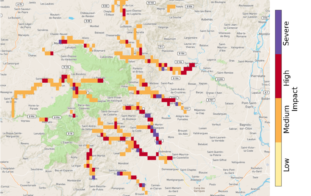
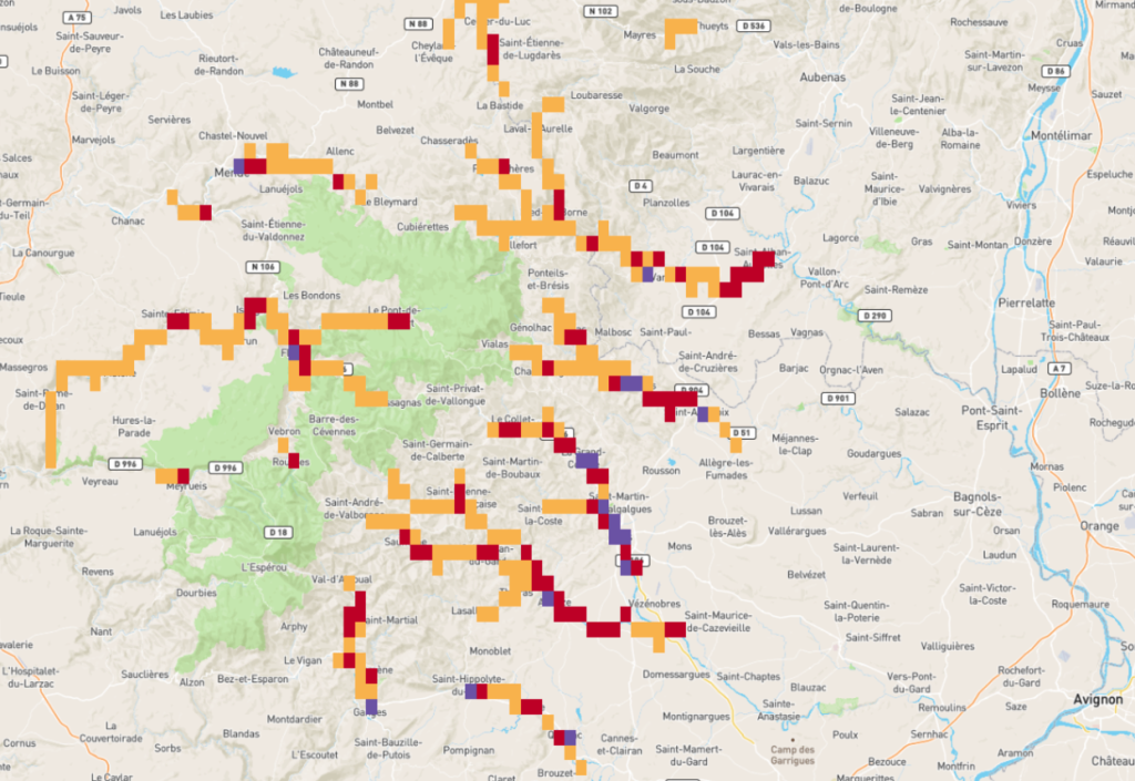
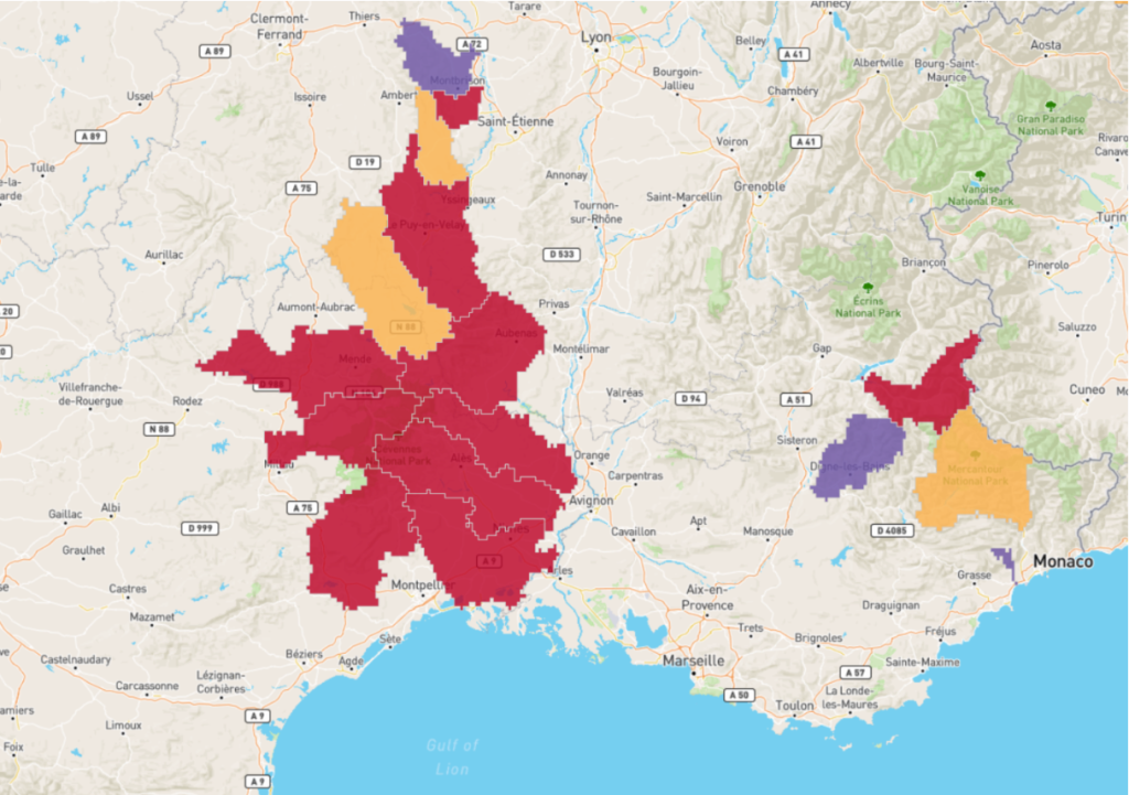
Figure 2 below shows examples of storm hazard and impact nowcasts. The hazard classes have colours white (no data), grey (no hazard), yellow (moderate hazard), orange (severe hazard) and red (extreme hazard). The three nonzero classes correspond to 10%, 50% and 75% percentiles of storm hazard levels in the pan-European training dataset consisting of a five-year period. The products shown in this example are based on the maximum level of each hazard type (heavy rainfall, wind gusts, hail and lightning). In addition, the uncertainty in the storm location is represented by the increasing transparency and spread of the ellipses as the forecast lead time is increased.
Flash flood impact layers
The Pluvial flood hazard in urban areas layer extracts information from the Hourly precipitation-radar nowcasting layer. The purpose of this layer is to give flood warnings with a focus on urban areas. An example is shown in Figure 3.
Block 3: Animated Flash Flood nowcasting
The flash flood nowcasts up to 6 hours are animated with a 1-hour window to show the evolution of near-future situation awareness.
Seamless 1h precipitation accumulation forecast
These 1-h precipitation accumulation forecasts are derived from a blend of radar observations and Numerical Weather Prediction (NWP) data:
- Radar Observations: a 20-member ensemble of 1-h accumulation generated with the algorithm for probabilistic nowcasting by extrapolation of radar observations SBMcast (Berenguer et al., 2011) applied to the gauge-adjusted OPERA radar composites over Europe (2 km, 15 minutes; Park et al. 2019).
- NWP Data: a 51-member ensemble of 1-h accumulation forecasts obtained by Numerical Weather Prediction with the ECMWF Ensemble Prediction System (EPS).
The blending technique (Wong et al. 2009) is applied for the first 6 hours and applies a phase shift and bias correction to blend radar nowcasts into NWP using a hyperbolic tangent weighting function. For lead times beyond 6 hours, the product relies only on the NWP forecasts.
The displayed accumulations correspond to the forecasts obtained with the control member.
Flash flood impact over the river network
Hourly forecasts of flash flood impact levels over the river network for the next 6 hours. This is created by combining an estimate of flash flood hazard with information about population and critical infrastructure asset exposure.
Hourly forecasts of flash flood hazard levels over the river network for the next 6 hours are estimated by blending the precipitation from OPERA radar mosaic derived nowcasts and forecasts from the ECMWF IFS (Integrated Forecast System) and accumulating these values on a channel network with a ~1.4 km spatial resolution. The accumulations on the channel network are compared to the reference values derived from a climatology created using: (i) 8-year gauge-adjusted OPERA data, and (ii) a dataset of 20-year reforecasts obtained with the ECMWF IFS (Integrated Forecast System).
The forecasted impact level is estimated by combining the hourly flash flood hazard forecasts with the exposure layer on a risk matrix. Both the flash flood hazard and exposure data are split into 3 categories to create the risk matrix. The low, medium, and high values for flash flood hazard indicate where there is a 5%-50%, 50%-80%, and >80% probability of exceeding the 2-year return period threshold. The categories for low, medium, and high relative combined exposure respectively capture the variation in population density and critical infrastructure in rural, suburban, and urban areas in Europe. For more information on the exposure data, please see the documentation for the exposure layer.
Flash flood impact over sub-catchment
This layer summarises the Flash flood impact over the river network layer over each sub-catchment. This sub-catchment overview is created by shading the sub-catchments according to the 90th percentile of the impact level of all cells forecasted within it. The use of the 90th percentile of impact (instead of the maximum) is to avoid communicating potentially misleadingly high forecast information to users based on single cell values.
Block 4: Flash flood past 24-h summary
To overview what has actually happened in the previous day, several auxiliary estimates based on the observations are displayed.
Precipitation accumulation (24h)
Daily precipitation accumulation estimated from gauge-adjusted OPERA radar composites.
Rain gauge accumulation (24h)
Daily rain gauge accumulations were reported from WMO SYNOP gauges over Europe and AEMET over Spain.
Flash flood impact summary over the river network (24h)
The maximum flash flood impact level over the river network over the past 24 hours. The impact level is estimated by intersecting a flash flood hazard forecast with the exposure layer on a risk matrix. Both the flash flood hazard and exposure data are split into 3 categories to create the risk matrix. The low, medium, and high values for flash flood hazard indicate where there is a 5%-50%, 50%-80%, and >80% probability of exceeding the 2-year return period threshold. This flash flood hazard is estimated by comparing hourly observations of catchment-aggregated precipitation (from the blending of OPERA radar mosaic with short-range forecasts from the ECMWF IFS (Integrated Forecast System) with reference values derived from a climatology created using: (i) 8-year gauge-adjusted OPERA data, and (ii) a dataset of 20-year reforecasts obtained with ECMWF Integrated Forecast System (IFS). The categories for low, medium, and high relative combined exposure respectively capture the variation in population density and critical infrastructure in rural, suburban, and urban areas in Europe. For more information on the exposure data, please see the documentation for the exposure layer.
The procedure above gives hourly impact levels for the river network cells. To provide a summary over the 24h period, the impact shown in each river network cell is the maximum impact forecasted in the 24 hourly forecasts produced.
Flash flood impact summary over sub-catchment (24h)
The maximum flash flood impact level over the river network over the past 24h. The impact level is estimated by intersecting a flash flood hazard forecast with the exposure layer on a risk matrix. Both the flash flood hazard and exposure data are split into 3 categories to create the risk matrix. The low, medium, and high values for flash flood hazard indicate where there is a 5%-50%, 50%-80%, and >80% probability of exceeding the 2-year return period threshold. This flash flood hazard is estimated by comparing the hourly observations of catchment-aggregated precipitation (derived from the blending of observations from the OPERA radar mosaic and short-range NWP forecasts from the ECMWF IFS (Integrated Forecast System) with reference values derived from a climatology of 8-year gauge-adjusted OPERA data. The categories for low, medium, and high relative combined exposure respectively capture the variation in population density and critical infrastructure in rural, suburban, and urban areas in Europe. For more information on the exposure data, please see the documentation for the exposure layer.
This gives hourly impact levels for the river network cells over the previous 24 hours. The maximum value over this time period is identified in each river network cell. To then provide a quicker overview of the affected areas, this sub-catchment overview is created by shading the sub-catchments according to the 90th percentile of the impact level of all cells forecasted within it. The use of the 90th percentile of impact (instead of the maximum) is to avoid communicating potentially misleadingly high forecast information to users based on single cell values.
Block 5: Static Layers
Static layers contain information such as Exposure and Flood Area.
Exposure
The combined relative exposure of the population, health and education facilities, and transport and energy infrastructure in each grid cell. For transport, roads, railways and airports are accounted for. For energy infrastructure, all types of power plants are accounted for, but infrastructure for the distribution and transmission of electricity and gas is not. Cells showing greater exposure have one or more of a high population density; a high number of health and education facilities; and a large amount of infrastructure.
The data used to create this combined exposure layer are all openly available and either pan-European or global. GHSL Population (Global Human Settlement Layer) data from the 2015 epoch was used for population. For the other four exposure categories (health, education, transport, energy) a combination of OSM (OpenStreetMap) data and data from the ‘HARmonized grids of Critical Infrastructure in EUrope’ (HARCI-EU) was used. Each dataset was reprojected and cropped to the spatial domain covered by EDERA, then transformed for normality. The datasets were then rescaled between 1 and 2 to give them a common scale, added together, and then rescaled again. This gave the combined exposure layer shown in the map viewer.
Flood Area (T1000, T050, and T010)
Flood Area layers (T1000, T050, T010) indicate water depth across various flood scenarios, ranging from 0-15 meters.